Val de San Vicente
 Download the cheat sheet and go!
|
On the border of the Principality of Asturias, Val de San Vicente is the municipality that 2 of the 3 rivers in the region flow into. You surely haven’t seen a more beautiful way to unite the river and sea in the form of the Deva and Nansa Rivers and the Cantabrian Sea. And this is what the landscapes of the Tinas have to offer. Its villages include: Abanillas, Estrada, Helgueras, Luey, Molleda, Muñorrodero, Pechón, Pesués, Portillo, Prellezo, Prío, San Pedro de las Baheras, Serdio and Unquera. What will you find? 1 river path and 1 coastal trail, 2 estuaries, 3 historical routes, several beaches and, of course, fancy “corbatas!” You have to go back to Prehistoric times to find the first inhabitants of the municipality. They lived in the Salín and Rejo caves, where they quite literally left their mark on the walls. For example, in the case of the Salín, there are several outlines of hands painted. It’s a place that dates back to a Pre-Roman Era in the form of the Castro del Castillo in Prellezo. Here are the remains of an old coastal settlement. Neither of these places can be visited. The Torre de Estrada, which has been standing tall since the Middle Ages, was named a Cultural Interest Asset in 1992. Two pilgrimage routes pass right in front of the tower: the Camino de Santiago (the Way of St. James) and the Camino Lebaniego, which separate in Muñorrodero. A third historic route also passed through Val de San Vicente: Carlos V’s first trip to the peninsula in 1517 when he was still prince. Apart from its rich history, we can’t forget the high environmental value of the mouths of the Deva and Nansa Rivers: Tina Mayor and Tina Menor. Next, we’ll reveal more details and interesting facts about the ESSENTIAL things you need to EXPLORE:
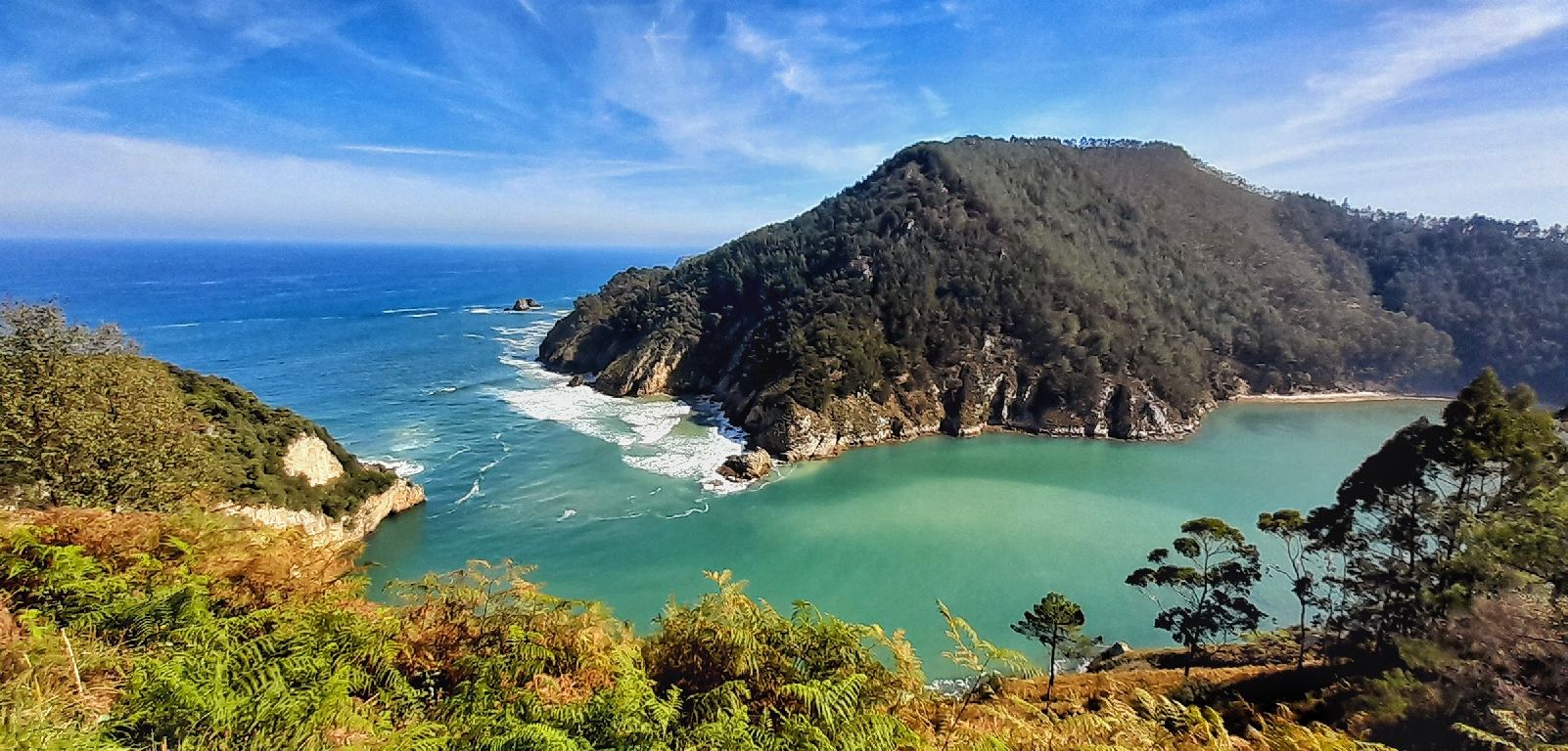
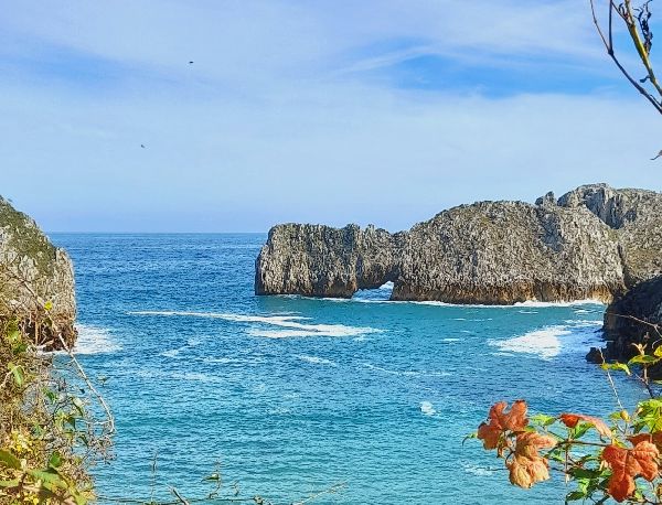
Near Pechón you can find the Tina Menor View Point. This estuary is where the fresh water from the Nansa River mixes with the salt water from the Cantabrian Sea. Apart from the beauty of the landscape, the estuary serves a great environmental purpose. Over 30 different species of birds use it for shelter. Moreover, it’s protected as a Special Conservation Area (ZEC) under the name Western Estuaries and the Oyambre Dune.
Next to the road that goes from San Vicente de la Barquera to the Nansa valley, and atop a crag, sits the medieval Tower of Estrada. It’s originally from the 8th century, although it was rebuilt in the 12th century. It’s a complex with a wall, tower and chapel. Its defensive wall still preserves some battlements, arrow-holes and a trench dug out of dirt and rock. Attached to the tower is the San Bartolomé chapel from the 13th century. In the summer, it’s the setting for the “The resistance, reality and legend” exposition which is about the guerillas in postwar Spain. One of the most prominent figures of the resistance or “those that sought shelter in the mountains,” was Francisco Bedoya who was born quite close to the tower, in the village of Serdio.
“I am the Tower of Estrada Founded on this crag On this mountain I am older Than Velasco’s house And I owe the King nothing.”
Val de San Vicente is truly a paradise of small beaches. From east to west they are:
If you’re keen on walking, then we invite you to come walk along the Nansa River path, which not only used to be the old fishermen’s trail, but also part of the Camino Lebaniego. It passes through the municipalities of Val de San Vicente and Herrerías, between the villages of Muñorrodero and Puente El Arrudo. It’s 13 kilometers which could be separated into two legs: the first from Muñorrodero to Camijanes, and the second from Camijanes to the CA-855 road, between Puente El Arrudo and Otero. The first stretch is recommended for families, while the second one is of moderate difficulty. However, neither of them are suitable for a baby carriage. 1st leg: Muñorrodero – Camijanes In Muñorrodero, in the area of the cabins and cemetery, take the path that leads to the recreational area, which is where you can leave your car. Then you return a few meters on foot to start the route. The trail runs along the banks of the Nansa River and it’s not difficult. In fact, there’s even stairs and walkways in several sections along the trail. However, just be careful if it’s rained heavily because it’s a flood zone. Throughout the hike, you’ll see a forest right along the river, an area for climbing and shelters and walkways that fishermen used to cross the river. At the end of this leg you’ll find the Trascudia power plant, which is where the Supino River reaches the Nansa River in the form of a waterfall. 2nd leg: Camijanes – Puente El Arrudo To start this leg, you should take the detour at Los Collados towards Trascudia. Here, the trail has a greater incline and it’s been preserved in its natural state. After passing Tortorio bridge, you’ll reach the Trascudia hydroelectric power plant, which has been running since 1949. From that point on, you fully enter the path that runs through holm oaks and a riverside forest. You’ll then reach an access area that’s a little more complicated, Peña Sancho, where there’s a cable to help you pass the rocky area. Once you reach the bridge that connects Puente El Arrudo and Otero, you can extend the walk to the Iron Foundry of Cades. Technical information and recommendations: ► Starts and ends: Muñorrodero - Puente El Arrudo Notes: 1. We recommend downloading the track of the route on your phone.
We’re so fancy here that the “corbata” (necktie) is our crowning glory when it comes to pastries; so much so, that it’s a typical product of the area that’s crossed borders. It’s a puff pastry made with butter and a layer of icing sugar and almonds. They have the namesake of Unquera, however, there are more bakeries in the municipality that make them, as well. They’re great to have for breakfast or as an afternoon snack with hot chocolate.
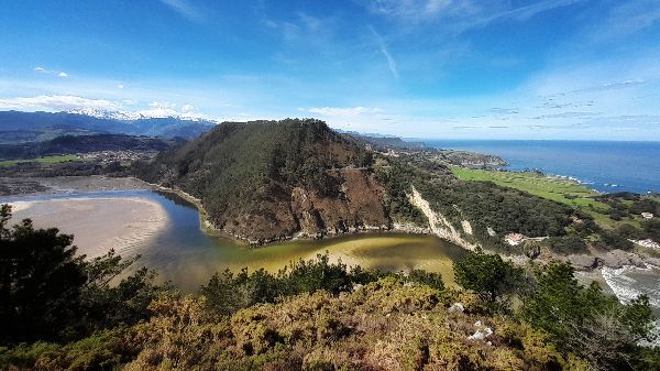
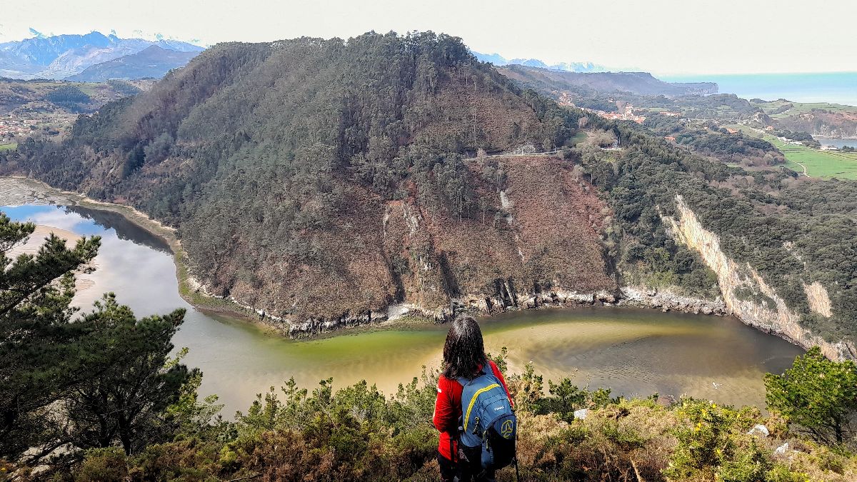
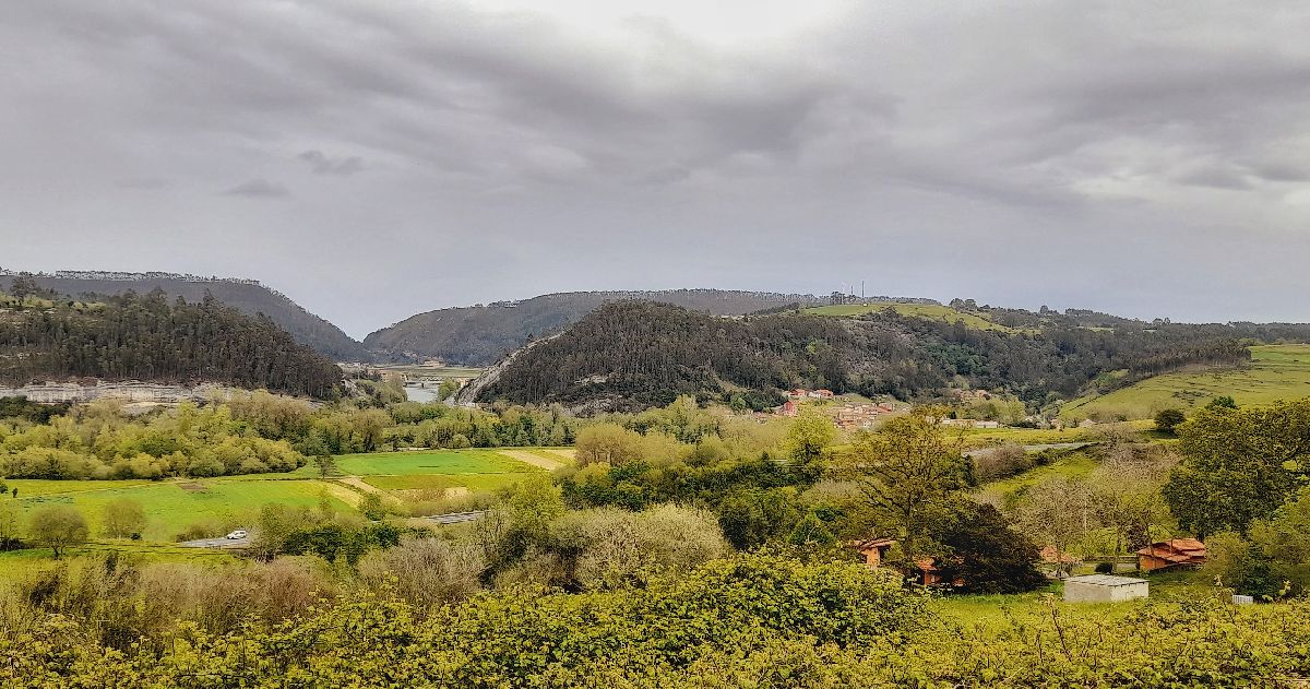
After flowing for more than 60 kilometers from Fuente Dé and through the La Hermida gorge, the Deva River reaches the Cantabrian Sea and forms Tina Mayor. The estuary borders with neighboring Asturias creating a landscape full of eucalyptuses, oaks and marsh vegetation. Down below is El Pedrero (also known as Pedreru) Beach, which is made up of small pebbles. Once you’re down there you can relax on a calm beach and marvel at the spectrum of the blues and greens of the water.
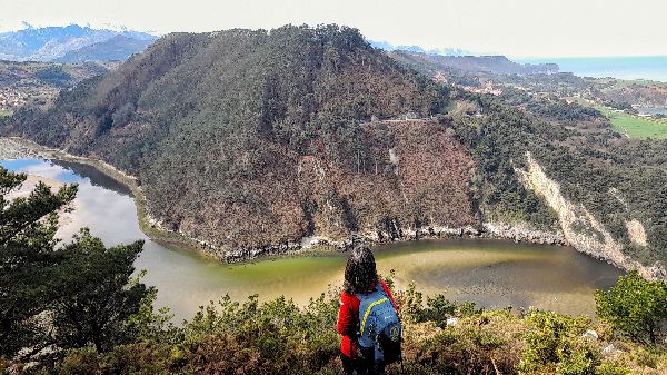
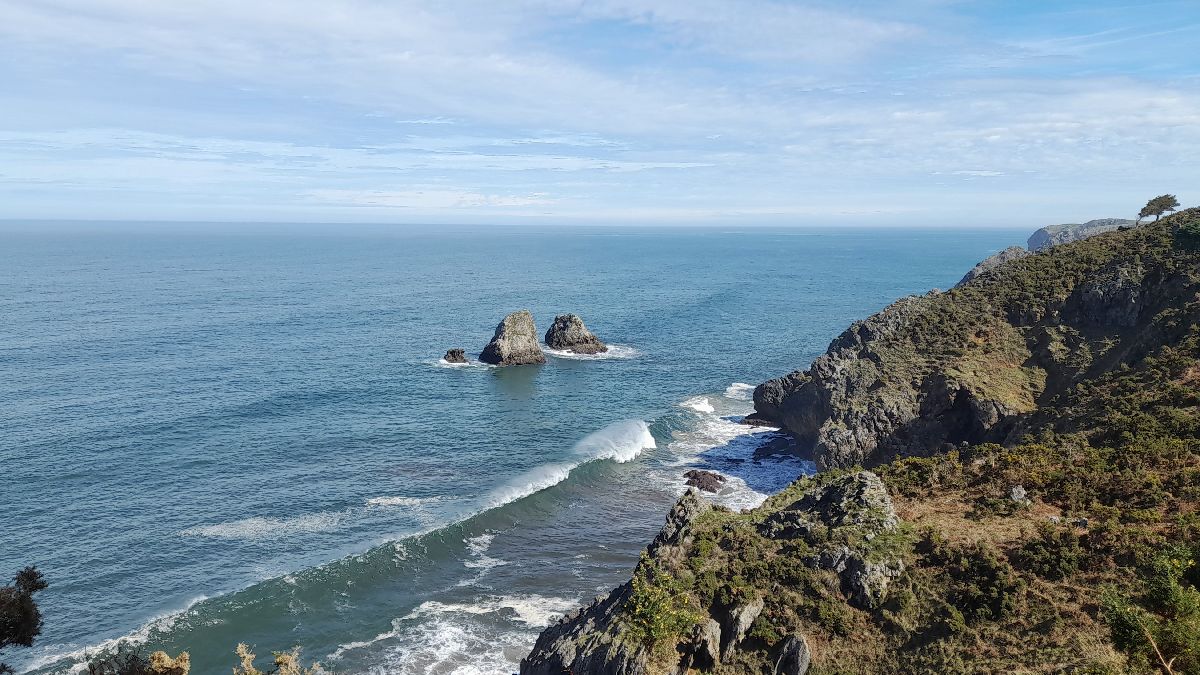
On this hiking trail you’ll have the chance to walk along the flat sierra of Jerra. These flat sierras of coastal plains were formed 480 million years ago, when the terrain was at sea level and exposed to the ebb and flow of the tides. In geology, these areas are called abrasion platforms. The wooded area along this trail is replete with eucalyptuses, pines, oaks and laurels. However, the most interesting are the views of the coastline and the Tina Menor estuary, which is part of the Special Conservation Area (ZEC) under the name Western Estuaries and the Oyambre Dune. The journey starts next to the church in Prellezo. The trail is signaled at PRS-252 and has yellow and white markers, although some of them may be missing. It’s best to download the track on your phone beforehand to avoid any confusion. At 1 km from the start, after passing the houses of Prellezo on the west, you’ll reach a fork in the road. You can do this hike in either of the two directions. The track we’ve included follows the path to the left. You’ll soon come across the stretch with the greatest incline. However, after that, the uphill and downhill sections are less steep and you’ll continue on until you reach a lookout point where you can see the entire coastline. About 2 km away from the viewpoint, you’ll find the fork in the road which will lead you back to Prellezo. Technical information and recommendations: ► Starts and ends: Prellezo Notes: 1. We recommend downloading the track of the route on your phone.
There are 4 Holy places of Christianity since the Middle Ages: Rome, Jerusalem, Santiago de Compostela and the Monastery of Santo Toribio de Liébana. The region of Saja Nansa has the privilege of being crossed by two historic pilgrimage routes: the Northern route of the Camino de Santiago and the Camino Lebaniego. ? The Northern route of the Camino de Santiago (the Way of St. James) In the 9th century, the tomb of Santiago (St. James) was discovered in what was known as Libredón forest, in the northeast of the Iberian Peninsula. A church is founded which the first pilgrims begin to visit. In the 11th century it was solidified as a pilgrimage center at a European level. It’s often said that there are as many routes as there are pilgrims; although it’s true that throughout time, several main routes were developed, like the Portuguese, the Silver, the English, the French and the Northern Ways. Within Saja Nansa, the Camino passes through the municipalities of Alfoz de Lloredo, Ruiloba, Comillas, Valdáliga, San Vicente de la Barquera and Val de San Vicente. Every year, thousands of pilgrims from all over the world pass through Saja Nansa on their way to Santiago de Compostela.
? Camino Lebaniego The Monastery of Santo Toribio de Liébana near Potes houses the Lignum Crucis, the largest fragment of the True Cross that is currently preserved. Since its arrival is the 8th or 9th century, Christians began coming to the monastery in order to pray to the piece of the True Cross. In 1512, Pope Julius II granted this place the privilege of the Holy Year every time April 16th –the day of Santo Toribio—falls on Sunday. The Camino Lebaniego connects the North and French Ways of the Camino de Santiago via the Vadiniense Route. All of these routes have been named UNESCO World Heritage Sites.
Emperor Carlos V was one of the most well-traveled kings, as has been documented by the chroniclers who accompanied him. His journeys are part of The Cultural Routes of the Council of Europe and can be found under the name: The European routes of Emperor Carlos V “Itinera Carolus V Imperator.” Under the section of Cultural Routes of Spain is where you’ll find Prince Carlos’s first trip from 1517, during which he crossed the Saja Nansa region. After the death of his grandfather Fernando the Catholic, he had to travel to the Iberian peninsula from Flanders to take possession of his lands as heir. This first trip was truly an odyssey: a fierce storm in the Cantabrian Sea caused the expedition to be split into two parts. The ship on which Prince Carlos was traveling, along with others, ended up in Tazones, on the Asturian coast. This is the start of a long journey to Mojados (Valladolid). He passed through the municipalities of Val de San Vicente, San Vicente de la Barquera, Cabezón de la Sal, Ruente, Cabuérniga and Los Tojos. They also spent the night in various towns in the region like San Vicente de la Barquera, Treceño, Valle de Cabuérniga and Los Tojos.
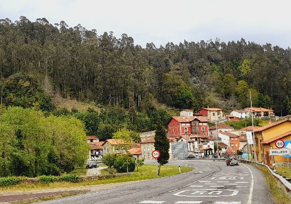
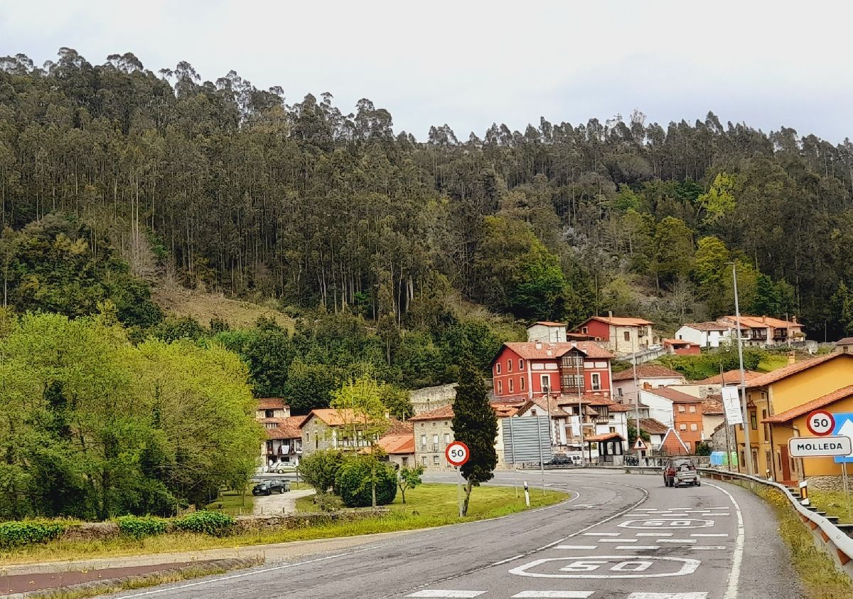
Between Asturias and Cantabria, the Deva River bears witness to a renowned canoeing sporting event: the Descenso Internacional del Deva (International Descent of the Deva River). This competition is held the last weekend of August or the first weekend of September. The sportspeople start at the Panes-Siejo bridge and travel 12 kilometers until they reach Unquera. Throughout the river you can see the canoeists in Buelles, Vilde, Molleda or the bridge that connects Unquera and Bustio.
|


 Next to the lookout you’ll see the statue of the “Fisherman with his fishing rod.” This monument is the work of Portuguese sculptor and architect Antonio Coello. It’s quite representative of the fishing activity in the Tina. If you pay close attention, you may even see fishermen fishing on the rocks.
 TORRE DE ESTRADA (TOWER OF ESTRADA)
 For more information on opening dates and times, consult the Val de San Vicente town hall.
 BEACHES
 THE NANSA RIVER PATH
 CORBATAS
 TINA MAYOR

