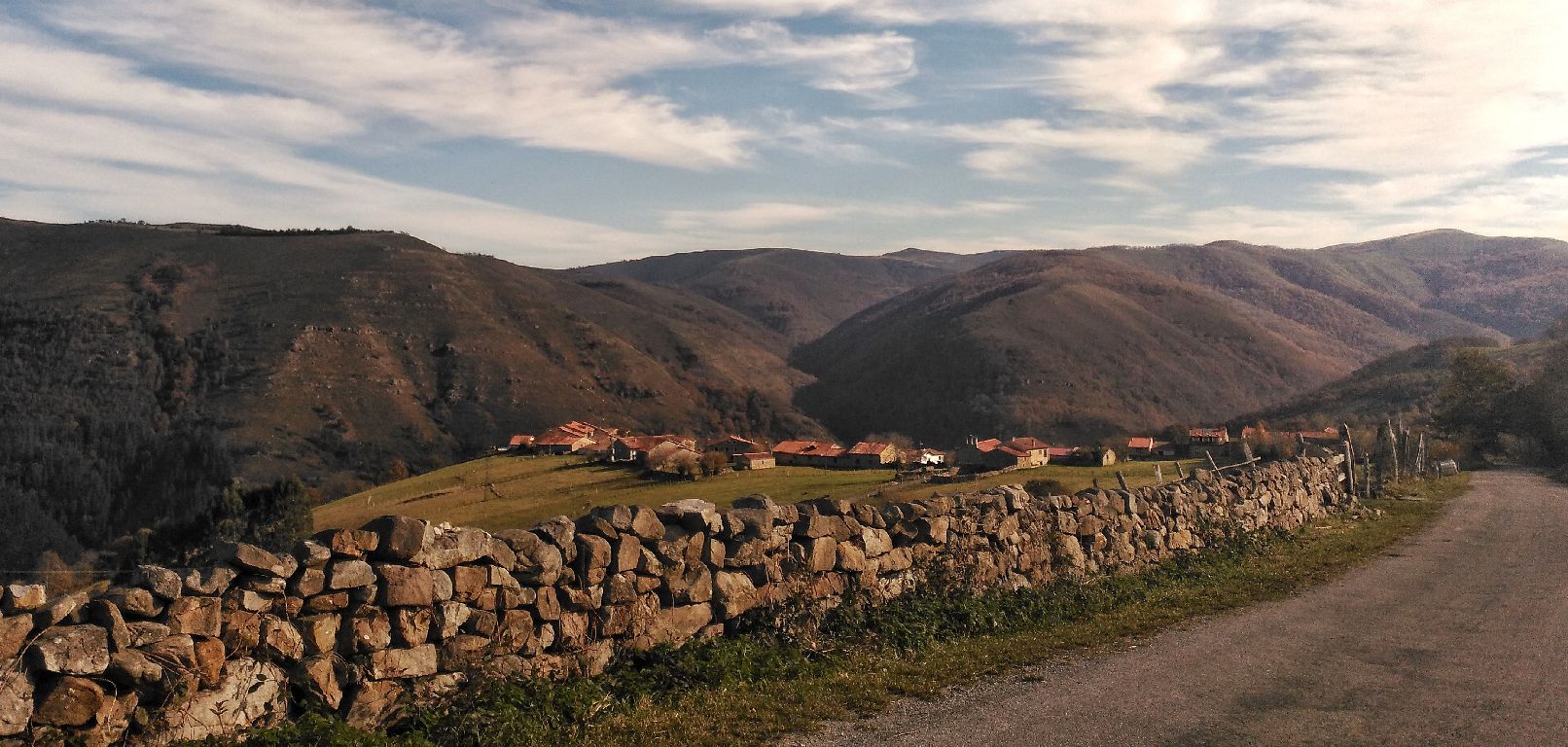
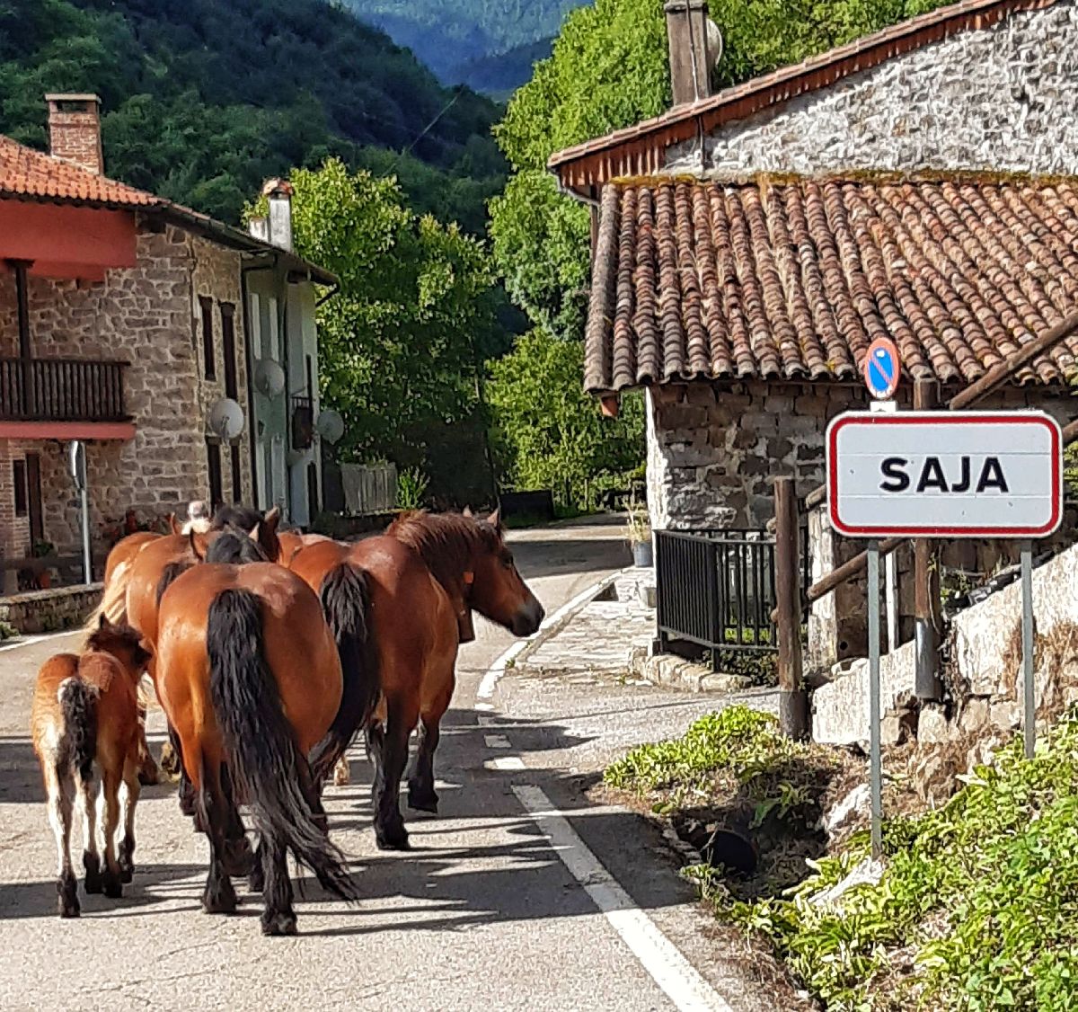
Los Tojos
 Download the cheat sheet and go!
|
Los Tojos is one of the municipalities with the highest environmental value since the majority of its territory is within the Saja Besaya Natural Park. Several rivers pass through this area, like the Saja, Argoza and Cambillas Rivers. It consists of the towns: Bárcena Mayor, Colsa, Correpoco, Saja, El Tojo and Los Tojos. And what do they have to offer? A different landscape every 4 months. It’s a place where you can go hiking, cycling, or snowshoeing depending on the season. And after doing those activities, you can have a bowl of montañés stew or a wild game dish and end with a walk through the beautiful streets of Bárcena Mayor or Los Tojos. What do you think of the plan? Later on we’ll give you some options and tricks to plan your trip. As a brief historic introduction, you should know that Los Tojos has been a means of communication with Castile since the Roman Empire. As the 9th century was the time of repopulation of the meseta, many people who lived on this side of the Cantabrian mountain range emigrated to Castile following the route known as the Route of the Foramontanos. In 1517, a young 17-year-old prince spent the night in the village of Los Tojos. He was on his way to Mojados (Valladolid) to be crowned Carlos I. He’d later be more commonly known as Emperor Carlos V. It was also an important commercial route: artisans in the area went to the markets and fairs in Castile to sell their “Garaúja.” This name refers to the traditional wooden agricultural tools and home utensils that were carved during the long winters. They sold these products or bartered them for flour and wine. Nowadays, the CA-280, which opened in the 19th century and goes through the Palombera mountain pass, continues to connect the meseta and the coast. It’s one of the most beautiful scenic routes that you have to come see. Now, we’ll reveal more details about the ESSENTIAL places you need to EXPLORE, and interesting facts and clues that will make your visit more fun.
Bárcena Mayor has a variety of reasons to be one of the must-see stops on your visit to the area. For instance, it’s the only village within Saja Besaya Natural Park, it’s part of the Historic-Artistic Grouping and was named one of “The Most Beautiful Villages in Spain.”The meaning of “Bárcena” is a flat place beside a river, and in this case, Bárcena Mayor sits along the edge of the Argoza River. The architecture of the houses takes you back to the Cantabria of the 17th and 18th centuries. If you’re a sportsperson, the village is a starting point of many hiking trails like Ozcaba, the Fuente Clara Trail or the Pozo de la Arbencia.If you love great food, it’s the perfect place to nourish your body and soul. Keep in mind that to visit the village, you must leave your car in the parking lot at the entrance of town.
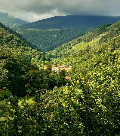
In the area, there are lots of places where you can disconnect from your daily routine and connect with Mother Nature. If that’s what you’re looking for, then come to the Saja Besaya Natural Park. Here’s some interesting information so you can visit: 1. How big is it? It’s about as big as 24,500 football fields! 2. How can I get in the park? The municipality of Los Tojos has various entrances:
3. What time of year should I go? That’s easy, every season has surprises in store for you! 4. Warning:
Los Tojos and Colsa are guards of the municipality, meaning that they’re the highest villages and guarantee some amazing views! It’s an easy 1.5-kilometer walk in which you’ll be able to see the way the towns were structured in a row. In fact, Los Tojos is one of the best examples in Cantabria. And one of the best places to appreciate this is halfway between both villages. You’ll notice how Los Tojos is like a snake of houses lined up along the old road to Castile. Two houses that especially stand out are Casa de Los Perros (The Dog House), which has a coat of arms, and La Colodra. On the walk, pay special attention to the eaves, balconies and doors of the houses. You’ll find authentic filigrees carved into the wood. Wood is one of the economic resources in the area. In fact, it was so important, that apart from the “Garaúja” craftsmanship, the Los Tojos School of Montañés Furniture was founded and had great significance in the 16th and 17th centuries. Located on private property, shortly before entering Colsa, is the El Dujo Fountain on the right. This construction is attributed to having Visigothic origins. You’ll notice that Nuestra Señora de las Nieves (Our Lady of Las Nieves) church is practically in ruins. There was a time in which Colsa went through a period of depopulation. Nowadays, it’s started to become repopulated thanks to establishments catered to tourism and homes, some of which being second residences. One street that that is very typically “montañés” is the row of houses along La Palma street, where houses with stables and barns are interspersed. You can continue your walk up to the Peña Colsa viewpoint. Next we’ll tell you all about this place with STUNNING VIEWS!
If you want to prolong the previous walk, then continue on to the Peña Colsa lookout point. At the village exit, there are two roads: straight ahead is the old road to Castile; while the road to the right will lead you down to the lookout point. You’ll notice a monument honoring Epifanio Sánchez Balbás, Colsa’s favorite son, as well as spectacular views of El Tojo, and the mountains of La Concilla, La Frechilla, La Colladía, Negreo, and of course, Peña Colsa. If you’re quiet and observant, you may see a few animals: deer, roe deer and birds like the griffon vulture, as Peña Colsa is their home. If you’re a hiker and want to continue walking, you’ll see a path that goes down to the village of Saja. This is the old road cart drivers used which zigzagged to ease the steepness.
Do you want to walk a route that was transited for hundreds of years? This trail is part of the old road to Castile that was still in use until the 19th century. The current road, CA-280 through the Palombera mountain pass, was opened in 1896, thus rendering the old one useless. Many have passed through here, like the Foramontanos in the 9th century, King Carlos V in 1517 when he was still a prince, and hundreds of merchants and mule drivers on their way to the Castilian meseta. The route unites the municipalities of Cabuérniga and Los Tojos. It’s simple, with very little incline and beautiful views. Since it’s linear, you can start in either Llendemozó or Correpoco. Throughout the route, you’ll see the village of Llendemozó, which was practically forgotten for a long period of time and where you can find the San Antonio Hermitage. Its saint is celebrated on August 14th and it’s the perfect time to see its interior: the wooden ceiling is painted with blue, red and yellow flowers and leaves. It’s one of the few that still remain in the area. Shortly before reaching Correpoco, you’ll come across a shrine. The shrines are small structures with religious symbols and they are located along the old paths. They were places where the walkers could pray or put themselves in the saints’ hands. This shrine in particular is a bit larger than usual because it also served as an “asubiadero.” In Cantabria, “ponerse asubio” means to take shelter in bad weather. Therefore, in this case, its purpose was twofold: it protected the travelers both physically and mentally. Technical information and recommendations: ► Starts and ends: Correpoco / Llendemozó Notes: 1. We recommend downloading the track of the route on your phone.
Getting to know the gastronomy of the place you visit gives you the chance to relive its history and, above all, understand the region’s economy:
Look at all the things the gastronomy can teach us! Now all you have to do is taste and savor “our delicious history”.
This section is separated into two parts so you’ll be able to learn more in-depth about the municipality of Los Tojos. First, we’ll recommend some routes throughout the natural park; then, we’ll explain some routes that historically prominent figures traveled through in the past.
We’re going to start by moving our legs and get your heart pumping with two trails. Both are within the Saja Besaya Natural Park and the starting point is in Bárcena Mayor: ► POZO DE LA ARBENCIA This track is linear. You’ll see white/yellow signs because it follows the PR-S113 Route of the Puertos de Fuentes, however, they are incomplete. There are also signs for the MTB category of the “Los 10000 del Soplao” (The Soplao 10,000) sporting event. Although the route is not difficult, we recommend you download the track on your phone beforehand because there are some areas with poor phone and internet reception. The starting point is the Bárcena Mayor parking lot. You go through the whole village using the upper road without turning to the right. Right away you’ll exit the village through a forest path which will lead you to Castrillo recreational area just over 2 kilometers away. You’ll notice that the Lodar and Queriendo Rivers converge before the recreational area; from this point on, it’s known as the Argoza River. From Llano Castrillo, continue straight ahead, using the Lodar River to guide you. The ending point is Pozo de la Arbencia, which is located in Hermandad de Suso. It’s not next to the path, so you have to cross the river and access it through a small trail. The Fuentes and Hormigas Rivers converge here. Take the same path back to return. This route can be done on foot or by mountain bike. Technical information and recommendations: ► Starts and ends: Bárcena Mayor Notes:
► FUENTE CLARA HIKING TRAIL To begin the Fuente Clara hiking trail, follow the directions of the previous route of Pozo de La Arbencia, towards Llano Castrillo recreational area. Shortly before this point, to the right, there is a cattle chute. The chutes are enclosures that are used to vaccinate, clean or gather the cattle. Right in front of the enclosure, there’s a sign indicating the Fuente Clara hiking trail. From this point on, you’ll start to go uphill. The sights are beautiful and they vary depending on the time of year you visit. The path is quite clear; however, since there are no signs, we recommend you download the track on your phone beforehand. As you’re going down to the Lodar River, you’ll come across a bridge, under which is the Poza Negra (Black Pool). After crossing the bridge, there’s a forest trail. If you go to the left, you’ll reach the Pozo de la Arbencia. If you go to the right, you’ll be led back to the Llano Castrillo recreational area and the cattle chute, which was the start of the trail. Technical information and recommendations: ► Starts and ends: Bárcena Mayor Notes: 1. We recommend downloading the track of the route on your phone just in case. There are signs, but there’s no phone reception.
Thousands of people throughout history have transited the different routes in the region. Some have even left their mark by formally naming these historic routes. In the municipality of Los Tojos, we’ll mention two of them in chronological order: the Route of the Foramontanos and the Route marking the arrival of Prince Carlos in 1517. The latter pertains to The Cultural Routes of the Council of Europe under the name: The European routes of Emperor Carlos V. ► Route of the Foramontanos To explain and understand this route, you need to mentally go back to the 9th century. In that early medieval period, there were Christians along the Cantabrian mountain range, while there were Muslims on the Castilian side. Due to the weakness of the Emirate of Córdoba at that time, the Muslims suffered several attacks and started to retreat south, thus leaving an uninhabited strip north of the meseta. Some documents date back to the year 814, when people in the north crossed the Cantabrian mountain range to repopulate those uninhabited areas. This repopulation movement would begin in various areas in the north of Spain; and nowadays, Castile is a land of opportunity for many. In the case of the Saja Nansa region, the starting point was Mazcuerras and Cabezón de la Sal, and it went around the entire Saja valley. It’s what is known as the Route of the Foramontanos. The route goes up to Brañosera (Palencia). In a document dated back to the year 824, Count Munio Núñez granted Braña Osaria a Municipal Charter called “Fuero de Brasoñera.” The document’s purpose was to organize the repopulation by recognizing the settlers’ rights to the land. In it, he makes reference to the “the road that Asturians and Cabuernigos used to travel.” ► Route marking the arrival of Prince Carlos in 1517 Emperor Carlos V was one of the most well-traveled kings, as has been documented by the chroniclers who accompanied him. His journeys are part of The Cultural Routes of the Council of Europe and can be found under the name: The European routes of Emperor Carlos V “Itinera Carolus V Imperator.” Under the section of Cultural Routes of Spain is where you’ll find Prince Carlos’s first trip from 1517, during which he crossed the Saja Nansa region. After the death of his grandfather Ferdinand II, he had to travel to the Iberian peninsula from Flanders to take possession of his lands as heir. This trip was truly an odyssey: a fierce storm in the Cantabrian Sea caused the expedition to be split into two parts. The ship on which Prince Carlos was traveling, along with other ships, ended up in Tazones, on the Asturian coast. This is the start of a long journey to Mojados (Valladolid). They spent the night in various towns in the region like San Vicente de la Barquera, Treceño, Valle de Cabuérniga and Los Tojos. The journey was recorded and we’ll leave you with here: Chronicle by Laurent Vital |


 A fun fact about Bárcena Mayor is that, if you’re observant, you’ll find several sundials. Only one of them is “on time” and facing the right direction, though. It’s your mission to find it.
 If you want to find out more about Bárcena Mayor, click on this link:
  SAJA BESAYA NATURAL PARK
 FROM LOS TOJOS TO COLSA
 PEÑA COLSA VIEWPOINT
 ROUTE FROM CORREPOCO TO LLENDEMOZÓ
 GASTRONOMY
